- The core of the heat will be centered across the eastern rockies and central plains states in june before shifting northwards as we head into july and august
- Drought conditions will persist across the central part of the CONUS and intensify across the intermountain west and southern prairies
- Normal precipitation is expected across the great lakes and northeast with an active severe weather season likely across the ohio valley, great lakes and ontario.
- Much warmer then normal temperatures will occur in the western great lakes with near to above normal temperatures in the northeast.
- Drier then normal conditions will continue across the southeast in june before much needed rains become more common in the second half of summer
The current IRI forecast predicts a warm biased la nada as we head into the summer. I think that this is likely given the current warmer then normal sub surface temperature anomalies in the pacific. A full blown el nino is unlikely with a -PDO allowing warm water to drift southwards. SOI values have been variable lately with changeable SST's. Important to note is the warmest SST's are focused across eastern ENSO regions which would help intensify the summer heat. This would also allow more Sub Tropical energy to send moisture into the southeast and gulf coast states.
CPC forecast:

Current SST's consist of a warm AMO tripole with east based warmth in the tropical pacific.

Analogs
For my summer analogs I focused on years with a +AMO, -PDO and neutral ENSO state coming after a weak la nina. For my analogs I used 1932,1936, 1937, 1952 and 2012. Here are the temperature departures from the blend of years.

Precipitation

The temperature trend on these years is very similar to my summer thoughts. Notice how the heat is centered across the eastern rockies, plains states and extending northeast towards the great lakes. Cooler weather is likely along the west coast in the -PDO regime but the intermountain west may end up hotter and drier then the analogs show. An active monsoon season is present across the SW causing near to slightly below normal temperatures. I am also expecting wet conditions across the southeast in mid to late summer which is showing up in the analog package and european monthlies.
I will break down each analog year individually.
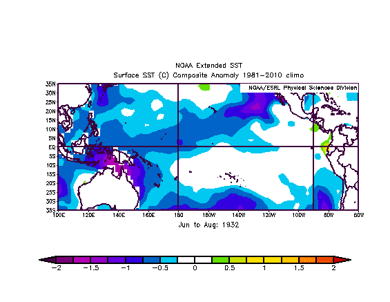
1932
This year had a moderate la nina in the winter season before a transition to la nada by the early summer. The warmest water temperature anomalies were centered in nino 1+2 which helped cause a hot summer across the central and eastern u.s. Dry conditions expanded northeast towards the great lakes region.
June to August SST's
Palmer Drought Index

Temperature Departure

1936
1936 was a weak la nina with a warm AMO and cold PDO horseshoe. This was a very hot summer across the western great lakes and plains states. I don't think this year will end up as hot as 1936 due to the neutral ENSO state predicted as opposed to a la nina which would enhance ridging in the mid latitudes.

Temperature Departures

Palmer Drought Index

1952
1952 had a downwelling easterly QBO with a neutral ENSO state coming after an el nino winter. The heat was centered further Southeast then I am expecting.

2012
I added last summer to my analog set because the ENSO trend was very similar along with the PDO and AMO states. I do expect a wetter and cooler summer across the northeast and eastern great lakes compared to last year. Notice the cooler anomalies across the southeast.

1937
This year came after three la nina years in a row which is very similar to our current ENSO state. Widespread warmth occurred similar to much of the 1930's and 1950's.

Tropical Forcing
This summer I am expecting negative OLR anomalies to develop across the indian ocean and maritime continent. This should work together with cooler SST's near the dateline with warmth off the coast of south america. The CFSv2 is pointing towards a northwards momentum transport between the equator and the tropic of cancer which favours more southern branch moisture and ridging in the central u.s. Phases 2-5 of the MJO/GWO will be common this summer in my opinion.

My Temperature Forecast

Precipitation Forecast:

 Reduced: 90% of original size [ 565 x 437 ] - Click to view full image


